Saturday, July 17, 2010

Hiking

After completing the biking event on Saturday, we rested and recuperated on Sunday.

On Monday we drove down to Mammoth Lakes to hike.

We decided to hike Duck Pass (#1 on the map above).
Total mile: 10+ miles
Started: 3:20pm
Finished: 7:50pm

The trail head is at the southwest edge of the Coldwater Creek parking lot. This lot is at the top of Coldwater Creek campground at the far (southeast) end of Lake Mary. You will pass several lakes along the way. Duck Lake lies beyond and below Duck Pass; the lake cannot be seen from the pass, but continuing south a short distance gives you a fine view.

to Arrowhead Lake (1.25 miles, one way)
to Skelton Lake (1.5 miles, one way)
to Barney Lake (2.5 miles, one way)
to Duck Lake (5 miles, one way)

As we had to hike over snow and the trail was difficult to follow we actually passed Duck Lake and made it to Pika Lake.

The next day, we hiked to Shadow Lake from Agnew Meadows (3.5 miles, one way) then took the John Muir Trail back to Devil's Postpile.

Total Mile: 13+-miles
Started: 7:00am
Finished: 3:00pm

This westbound trail to Shadow Lake descends into and crosses the canyon of the San Joaquin River before climbing into the Ritter Range. The trail follows an exposed face and climbs steep switchbacks.
Shadow Lake @9:00am

Rosalie Lake @ 10:30am

We then continued onto a long, rather boring part of John Muir Trail back to Devils Postpile. Therefore, no pictures beyond this point as it was just a long 5 mile descent.

Our next challenge would be to climb Mt. Whitney. As we did not have a permit to climb Mt. Whitney we needed to see if they had any permits. The permits become available at Lone Pine Ranger Station a day before your planed hiking day. They did and we would be able to climb the mountain. Since back-packing was not an option for us and we needed to complete the hike in a day and wanted to adjust to the altitude we decided to camp out in our tent at 8,000 feet elevation just below the trail head.

Driving up to the mountain.

As you can imagine, we did not sleep well, not only because of camping out (the first time for Mrs. Dalton), but as the Rangers at the station did a good job scaring us of bears. We did hear something going on outside of our tent, but we were too afraid to see what it was.
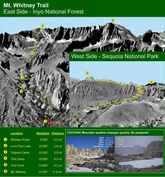
Mt. Whitney Trail
Total Distance to hike: 22mile / 35.4km
Trail Head Elevation : 8,360 feet / 2,548m
Mt. Whitney Summit Elevation : 14,497 feet / 4,419m


Starting out at Whitney Portal at 5 AM. Sunrise along the trail.


The trail from the parking lot to Lone Pine Lake is long switchbacks with a moderate grade. At the top of these switchbacks, there is a fork and a sign. To the left one goes to Lone Pine Lake, to the right one goes to Mt Whitney. The trail from this point to Mirror Lake is relatively flat.

Heading towards Lone Pine Lake


Lone Pine Lake


After passing through the Outpost Camp (at 10,360 feet, 3.7 mi / 5.8km from trail head), and Mirror Lake (at 10,640 feet, 4.0 mi / 6.4 km from trail head), the trail starts getting steeper and runs along a creek and leads you into the camp where most back-packers stay over night to climb to the summit on the following day.

If you look to your left (past the creek), at some point you can see Consultation Lake down below. You are not far from trail camp.

The Trail Camp at 12,000 feet where we ate lunch. And a very special guest.
Time: 9:30 - 10:15am

Beyond the Trail Camp at 12,000 feet is where you are likely to feel the altitude. From the camp you head for the face of Mt Muir at 14,015". The 96 switchbacks" (there are actually more than 140, apparently) take you to the Trail Crest. The switchbacks are a mild grade, but they are very long and the altitude kicks in. Mrs. Dalton thought she reached her limit at some points along this long hard climb up, taking rests every 5 minutes to breath. Below is a picture looking up at the summit of Mt. Whitney.

At the Crest you crossover to the other side, with incredible views of the Sequoia Park wilderness. After the long hard switchbacks, what a reward it was to see the open sky and the mountain ranges continuing as far as you can see.

At the Trail Crest (13,777" / 4,199m, 8.2mi/13.2km from trail head).
Time: 12:30pm

From this point, you turn right towards Mt Whitney. The trail goes up mildly. You will see three giant spikes sticking out of the mountain on your right-hand side. When you get to its base, you still have to climb some steep switchbacks.


The elevation really took its toll on me. We still had to hike half an hour after this photo

We made it to the top !!! Time: 2:25pm -- 9 hrs 25 min after we began climbing.


As we started to head back, rain clouds were forming westward and we saw lightning.


A little break while rushing against time to get back before sunset.

Finished - Tired, but happy that we successfully completed our hike.

On July 15, 2010, we climbed Mt. Whitney!
Woke up: 4:00am
Started: 5:00am
Finished: 8:25pm
Total Distance hiked: 22 mi / 35.4km
Total amount of water consumed: 1 gallon each.

Wednesday, July 14, 2010

Dalton Reunion

The Dalton’s decided a few months ago to have a reunion. Alec found a nice 1 day bike ride for us. Being Dalton’s we chose the death ride.

As always, Jim put the ride into perspective for all of us:


Harry flew in from the U.K and had a nice dinner with his cousin Shirley, her family, Willie (plus 1) and his family and Jim.

Yuko and I picked up Harry a little before 7:00 AM. To fellow XC09 this must be very surprising as during our cross country ride we always left a little later than the rest of the pack.
It is about a 7 hour drive from LA to La Casa Boga

Reunion dinner
The first and as it would turns out only Dalton flat tire was to our car tire. We changed tires and had the flat fixed.

We decided to take a training ride together and Mrs. Dalton (that would be the person I live with that I am related to by marriage) rode with us. Willie better be careful as we might have a new plus 1 or at least a plus 1 alternative.

For awhile we rode with Harry in front, Karen second, me third and Alec and Yuko. We rode so many miles together riding in this order and that brought back nice memories from last year. Order was restored in the universe.

Alec lives in Nevada and is close to the California border. We rode from Nevada and into California. Two state crossings today.

We then biked into town and had our first SAG.
After that the group headed back to La Casa Boga. As this was the first time that Harry had ridden this bike he wanted to test it going uphill. I decided to go with him and told him we would ride about 2 miles. After about 3.5 miles we decide to continue all the way to the top. As Harry put it “Ira, we will probably not have the opportunity to ride this again, so we might as well finish and climb to the top”. I could not see anything wrong with that logic so we did bike all the way to the top. In total, a 8 mile climb at 9% grade.
Getting our bikes ready

The day before the trip we went to obtain our registration packets for the ride. Where is Karen, She was on a very special pre-registration line which took twice the time as the 3 of us.
Alec and Karen were gracious enough to drive us around Lake Tahoe.


At the end of the day we stopped for drinks in Genoa which is the oldest town in Nevada.

The Daltons got up at around 4:00 AM. Mrs. Dalton got up around 3:30 and prepared a meal of pancakes, eggs, hash browns and bacon. We were ready to go.
We drove and parked our cars and we started off.

We all rode together for about 8 miles. The night before Alec and Karen had told us that we should ride at our own pace so as we started up the first ascent of Monitor Pass I started to distance myself from the rest of the Daltons. Little did I know that for the next 13 hours I would be riding alone the rest of the day.

There are 5 passes that you are trying to climb in 1 day. Each one is a little different than the other. Below are my impressions of each of the passes.

Monitor Pass – This is the first and easiest pass. It is a gradual climb and all riders are good mood as we have just started and the excitement of what we are undertaking is all let out in energy expended.

Monitor pass – Front Side:

Karen had recommended two strategies for the SAG – If you go to the bathroom eat your food while you are on line and try to limit the stop to around 5 minutes. The first one was easy to do, but I think I spent about 10 minutes in total at the first SAG. As the day progressed, the SAGS would be progressively longer.

We then proceed on a nice little downhill. As you are going downhill the thought going through your mind is control your speed and, “gosh, we are going to have to climb this hill going back”.

Monitor pass – Back side.

After resting at the SAG for about 5 minutes, I continued. This is all uphill. For those XC09’s it was similar to the climb in the Green Mountains in Vermont. You just get in your climbing gear and pedal. During my ascent I saw Alec going downhill. He was easy for me to recognize as he was wearing his CrossRoads jersey.

Once at the top you bike down the front side, so once again it is all downhill.
Ebbetts Pass – Front Side
This was by far the most difficult pass. You are climbing and climbing and you think that you are almost at the top, but you are still only at an elevation of 7,000 feet. The elevation at the top is close to 8,700 so you know that you have a long way to go. You talk with other bikers (okay- I probably did most of the talking) to pass the time. This was the first time where I experienced cramps. My bib number was falling off (it was on the back of my jersey and I could not see) so some riders told me that it was about to fall off. It was a good excuse to stretch my legs. This was around the 60 mile mark and there were only 70 more miles to go!!! Sometime after that we passed a person who was offering a 20 minute massage for $20. I was tempted, but continued on at a slower pace.
Arriving at the top was a good feeling, but I was a little worried whether I could continue with my leg cramps. My new strategy was to eat a lot of bananas and salty food at the SAGS. I also started to stretch out the time I spent at the SAGS. I spent around 30 minutes at the top.

Also, what helped in recovery was there was always a nice little downhill where minimal if any pedaling was needed. It was 6 miles all downhill to Hermit Valley and another SAG and another 30 minute rest and stretch.
At Hermit Valley, they affix your 4th sticker on the back of your bib. Each sticker indicates that you have completed a pass.

Ebbetts Pass – Back Side
From Hermit Village, you climb the 6 miles that you just rode downhill. Again my legs started cramping up, but I made it to the top. From the top there was a nice 10 mile downhill Ebbetts Pass. I saw Harry and Karen as I went downhill and Alec was resting under a tree. I biked into the designated lunch area and another 30 minute rest. I had biked 80 miles and 50 more to go.
Carson Pass

This is the last pass. The elevation and grade were not as difficult as others that day, but my legs were cramping more frequently. From mile 92 – 100 I pulled over to the side at least 3 times. One of my fellow riders was kind enough to give me two electrolyte pills. This got me to the top of Pickett’s Junction. I rested there for 45 minutes and then continued on to the top. I was really lucky as the grades were only about 6% until you got to the last 1.5 miles. They gradually increased and I pulled over to the side. I was not going to give up until I got to the top. I finally arrived at the top and when they affixed my last sticker and gave me my pin (signifying that I had made it, my left leg really tightened up and I could not move. Once again, another kind rider gave me some electrolyte pills for the trip back down. I managed to get to the purpose of climbing this hill. An ice cream sandwich bar awaited me!!!
Each rider that completes the DR signs a poster indicating they completed all 5 passes.
Below is me signing that board:


After resting for another 45 minutes and after one short uphill to start the next 20 miles or so were pretty much all downhill. I biked back to where we parked our cars and Karen and Alec cheered me on as I completed the ride.
My rider's bib with the 5 pass stickers and the pin you receive for completing (lower right hand side star)


Karen and Harry had ridden together, but in order to complete Karen told Harry to go ahead and try to complete all passes. Harry was able to meet the last two check-point designated arrival times by 4 minutes each and he completed the 5 passes as well. That is pretty amazing as that was the second time that he had ridden that bike. Karen completed 4 passes and Alec completed 3 passes.

Ave. MPH – 12.6
Start time: 5:35 AM
End time: 6:05 PM
Actual bike time: 9:55:52
Total miles 126.3 (I forgot to turn on my odometer a few times after resting at the SAG)

We returned to the house and below we celebrate at La Casa Boga.

And so that concludes the Dalton reunion of 2010. A good time was had by all and although a year has passed since we have seen each other, we picked up right where we left off from 2009 which left this Dalton with a very nice feeling inside.